Some call it the West Approach Bridge North. Others call it the new 520 bridge’s half-funded, half-constructed band aid for reaching mainland Montlake while the state legislature twiddles its thumbs over a transportation package. Like it or not, WABN construction will begin later this year with completion set for fall 2016. Here’s a closer look at what WABN will bring to the neighborhood.
Last year’s Montlaker post Good and bad in the new West Approach Bridge North covered the WABN basics, including…
- a new 3-lane elevated viaduct across Union Bay
- relocation of the Lake Wash Blvd exit ramp to 24th Ave E (the ex-MOHAI ramp)
- a 14′ wide regional trail across the new floating bridge.
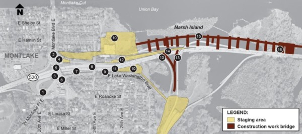
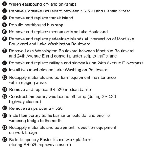
Since then WSDOT has released its Community Construction Management Plan with further information about the two-year project. Here’s a helpful map and list of WABN work items happening in Montlake (warning: this map, buried deep in the CCMP, is labeled “Anticipated Nighttime Construction Activities”)…
Included in this WABN phase are several mitigation projects, including a new Arboretum multi-use trail, wetland mitigation at the WSDOT Peninsula and Bryant Park — a restored shoreline at the foot of Brooklyn Avenue next to UW. However, the WABN plan is pretty thin when it comes to mitigating local mobility impacts. Two areas that will receive a bit of attention are Montlake Blvd over 520 and the intersection of Lake Washington Blvd and 24th Ave E, which will be the new location of the existing Arboretum exit ramp.
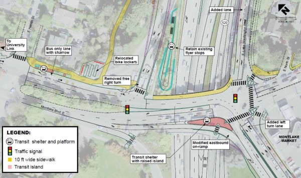
The improvements to Montlake Blvd reportedly will include new curb ramps and a rebuilt southbound transit island. At a January meeting with community representatives, WSDOT officials stated that metal railings separating pedestrian areas from traffic lanes would also be included. The basic lane configuration will remain mostly as is, except for the westbound Montlake Blvd exit ramp which will have two lanes terminating at a new signalized traffic light and the eastbound Montlake Blvd exit ramp will terminate with an extra left turn only lane. The northbound transit stop and bicycle lockers will relocate north toward Hamlin. The flyer stop? It stays… for now.
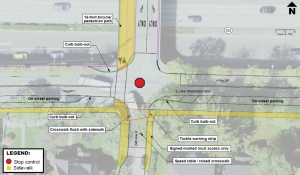
The quiet overpass at 24th Ave E serving McCurdy Park (and ex-MOHAI) will become the landing site for the Lake Washington Blvd exit ramp relocated from the Arboretum. To handle all that new traffic — and the existing bicycle traffic heading to and from the Montlake Bridge — the intersection will be reconfigured with a new flashing four-way stop signal, curb bulbs to shorten the pedestrian crossings, and a raised crosswalk at the entrance to 24th. Neighbors living nearby were divided on making 24th Ave one-way northbound to prevent exiting highway traffic from continuing south through residential streets, so 24th Ave will remain two-way.
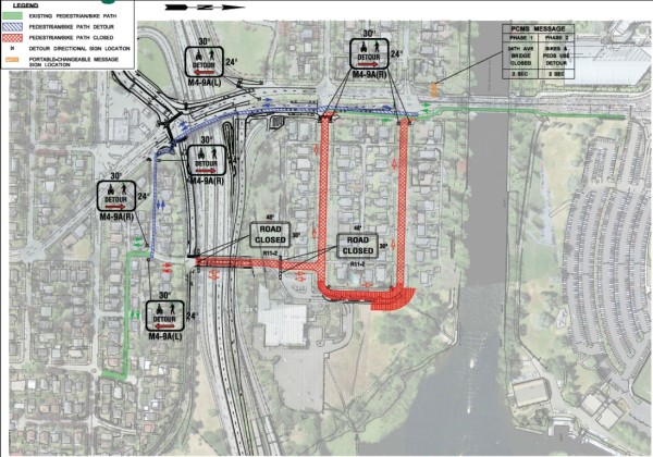
One major construction interruption will impact cyclists using the popular bike route through 24th & Lake Washington Blvd. The ex-MOHAI ramp will close for several months for partial reconstruction at its north end, meaning pedestrians and bicyclists will have to detour one block west to the mean streets of Montlake Blvd. The detour will use the East North alley marked in blue in this plan:
Politically, there is no funding available for continuing the 520 replacement beyond the WABN phase, at least while Olympia stagnates over a transportation package with $1.5 billion needed complete the job. “We’re going to try to get the Democrats back in control of the state Senate,” said Senator Jamie Petersen. “It doesn’t look like we’ll get a transportation package done with Republicans in control, and until we do that, it’s hard to see how we get 520.”
More WABN converge in the Montlake Flyer can be found here. WSDOT’s WABN page has official info and links here. As always, send questions and comments to SR520bridge@wsdot.wa.gov.
Art haug says
Rainer,
Thank you for the report.
Will the trail across Marsh and Foster Islands be open at all during this fiasco?