A major new investment in safe streets through Montlake is in the works, and the Seattle Department of Transportation wants to hear from you. Earlier this year, SDOT announced a “complete streets” project for the 23rd Ave corridor through the Central District that would repave the road and improve access for transit, pedestrians and bicyclists. With an improving budget situation, the plan is now being extended north to SR-520 through Montlake.
While the $46 million repaving project is likely still a few years away, planners are moving forward now on a new Neighborhood Greenway parallel to 23rd/24th Ave on the north slope of Capitol Hill and through Montlake. The route would continue on residential streets between Boyer and 520 that are potential greenway routes in the Bicycle Master Plan — either 23rd/22nd Ave or on the existing 25th Ave bikeway, depending on which parallel route is selected.
So what exactly are neighborhood greenways? SDOT defines them as…
Neighborhood greenways are residential streets where directional signage guides people along the route and traffic calming measures reduce traffic speed and volume, discouraging drivers from avoiding arterials by cutting through on neighborhood streets. Greenways can be especially beneficial for families, children and seniors who might find these routes more comfortable than busier nearby streets. Local access to homes along neighborhood greenways is always preserved, and there are usually minimal, if any, changes to on-street parking.
Thanks for not touching on-street parking, SDOT. Neighbors can be militant about parking.
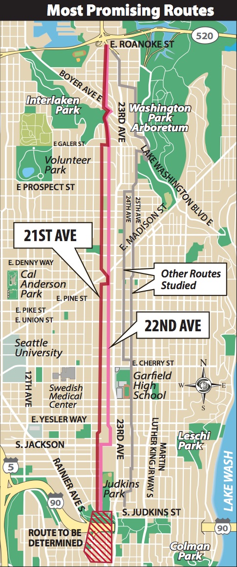
If the city wants to repave 23rd/24th Ave, why build greenways on parallel streets?–why not just make the arterial itself safer for pedestrians and cyclists? At an open house in March, SDOT presented options for widening the sidewalks and adding a two-way cycle track along 23rd through the CD, however they determined that the street width through the corridor was not sufficient to fit it all in (so much for “complete”). Their preference is to optimize parallel residential streets for walking and biking instead. Here are the options:
The preferred option of 22nd Ave (in red) provides a reasonable grade on the north slope of Capitol Hill (steep — it is a hill after all — but better than other nearby streets). Unfortunately, SDOT’s map gets a little wonky as its preferred route is drawn on non-existing streets in Montlake, between Boyer and Lynn. We can forgive that, since planning is still conceptual, but it begs the question: what is the best walking and biking route up the north slope of Capitol Hill?
SDOT wants your feedback. A public open house this Wednesday, November 6th at Nova High School, will give neighbors a chance to weigh in on the plan. More info here. Want the city to improve sidewalks, fill potholes and reduce cut-through speeds on your neighborhood streets? Now is your chance to tell ’em how best to do it.


Leave a Reply