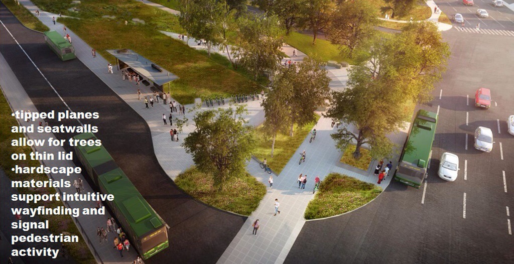
WSDOT is coming to the neighborhood on Thursday, September 11th with new plans for a shorter Montlake Lid — and high hopes of getting enough state funding next year to finish the SR-520 Replacement project through Seattle. Since the last design update in 2012, WSDOT has partnered with the City of Seattle to respond to critical public feedback asking for better pedestrian and bicycle access. Next week’s open house is the first unveiling of the collaborative effort.
So… a shorter lid? Yep. Previous plans from 2012 call for a 1400-foot-long landscaped lid over the future 520 from Montlake Blvd to Montlake’s eastern shoreline. This new plan calls for a much shorter 800-foot-long lid from a wee bit west of Montlake Blvd to 24th Ave East (the ex-MOHAI overpass). Goodbye eastern lid.
But wait, there’s more. A new bicycle-and-pedestrian-only bascule bridge over the Montlake Cut is now on the table, location yet to be determined. This follows a 2012 study concluding bike and pedestrian access on the Montlake Bridge is inadequate and even dangerous. The same study also concluded the vehicular capacity of the four-lane bridge is nowhere near its limit (it’s the inefficient intersections before and after the bridge that cause congestion, not the bridge itself), so there is no reason to build a second vehicular bridge. For now.
WSDOT will also present updated designs for a new Portage Bay Bridge, now including a 16-foot wide multi-use trail. Amazingly, it took “overwhelming” public comments in the year 2012 A.D. to finally convince WSDOT to allow people to walk and bike on what will be a rather large urban bridge. Important questions remain about how people will connect to the trail at either end.
Back to the “short lid.” WSDOT claims the plan improves neighborhood connectivity with better bike and pedestrian access compared to the 2012 “long lid” plan. Its shorter length doesn’t require mechanical ventilation and giant air shafts — and of course removing some 600 feet of concrete lid covering twelve lanes of highway would trim millions from the project’s unfunded need.
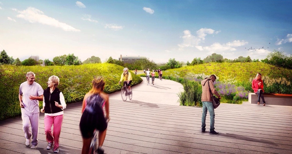
In lieu of the long lid’s eastern end, the short lid plan includes a “land bridge” over 520 with a trail connecting the Arboretum area to McCurdy Park and Hamlin Street. A land bridge is a lighter structure up to 70 feet wide that doesn’t support the weight of tall trees but is instead flanked by grassy mounds that block noise from the mega-highway below. It also has a much easier grade up and over for walkers and bikers. Check it out in the image at the top of this post.
Expect to see other improved connections to local streets and trails in the short lid plan at the public open house. One obvious question is: are such improvements made possible by reducing the length of the lid — or would they too be expected as common sense refinements to the long lid plan? Simply cutting back on hard-won mitigation during WSDOT’s “preferred alternative” process will likely not sit well. A shorter lid only makes sense if it affords new benefits that are unique to it.
SR 520 west side design open house — Thursday, September 11th, 4:30-7:30pm — Montlake Community Center


bidab says
According to WSDOT’s mailer and website the event is scheduled from 4:30-7, not 4:30-7:30 (http://www.wsdot.wa.gov/NR/rdonlyres/9B095FF2-FBE0-4843-8006-E55786FBCCE1/0/2014_Sept11_SR520OpenHouse_Mailer_Final.pdf)
Art Haug says
COLLABORATION?
WSDOT likes to brag about neighborhood collaboration. Having attended a few of their presentations over the years, one wonders about WSDOTs definition of the word collaboration. To many of us the collaboration was simply a ‘tell’ on WSDOTs part. They solicit Montlake input only to mask their lack of adequate park and neighborhood planning. The 11 September presentation looks to be another ‘tell’. All while the City of Seattle (CoS) and UW do nothing.
TRAFFIC STUDY???
The CoS 2012 traffic study was of limited scope and designed only to demonstrate that a second motor-vehicle bridge was unnecessary. As the study itself admits, the congestion that exists now will continue – and it will become worse with the addition of the 5th traffic light. If WSDOT & CoS wanted a traffic solution that would ease the Montlake congestion, they could do three things: 1) maintain the arboretum 520 access ramps, 2) build a diversion bridge to take the northbound 520 traffic directly to and from the Pacific Street interchange, and 3) revise the out-dated maritime law which currently allows one pleasure boat to open the Montlake bridge.
PUBLIC PROCESS???
I apologize for the cynicism, but it appears that WSDOT has been charged to do something – even if it is wrong. Why does the east side get fancy sound walls and large lids in an expansive suburban setting while our compact urban Montlake neighborhood gets minimal engineering solutions, ever-lasting congestion and an ever-shrinking noise-suppression lid? WSDOT only cares about traffic movement and CoS has ignored the problem.
R. Day says
No further construction piecemeal until a complete plan is presented and funds are available. How to get a public or legislative vote I do not know, but defer to our Legislators. The idea of 6 lanes going to 4 is appealing to move a vigorous debate on how the connections will work before anything is built. This is not denying connections, only to have them with lids and amenities appropriate to a neighborhood where people live. Noise and other pollution has to be contained, and health of all those involved and affected protected. Is there any consideration of the most efficient way to move cars and people and to value that in an equation that takes into account minimizing energy use (like idling cars, busses and other pollution sources)? State and City policy places limits on waste and pollutants, and protects health. The plan must place these concerns foremost.
Jeff P. says
Why not just stop the new bridge at the east end of Foster Island until and when they actually have funding and a really comprehensive plan on how to spend it?
Or, just build an acknowledged temporary noise cap and plop some pedestrian and bike paths on it. Save the trees and aesthetics until a couple years’ of experience with mayhem dictates a truly sensible redesign. (Sounds like that is nearly what they are down to at this point, regardless).
Walking/biking are going to be the best way to negotiate the resulting traffic jams. This whittling away of what “nice” features they promise our neighborhood based on funds that keep shrinking very much emphasizes who this project serves, and that isn’t Montlake, Broadmoor, Madison Park, near points of Capitol Hill & other Seattle neighbors who must pass through Montlake on their way east or towards UDub.
A safe bet is that no matter what, bridge designers will try to enhance eastside traffic flow to the University and I-5. Funds will be found for that. Poor access to/from Montlake & points south will assist. Plus we’ll all be using the abundant mass transit opportunities we have, right? Until something sensible comes along, this ever-shrinking local appeasement plan dooms us to noise, congestion & exhaust pollution in Montlake.
It seems that they keep coming to see how much we’ll beg for less of a bad thing.
Frank says
Keep in mind that WS-DOT’s pretty pictures are almost always much prettier than the reality of what gets built. The pretty pictures of have lots of grass and trees. The reality is mostly concrete and asphalt interrupted by with signposts and fences.
Kathy Laughman says
Thank you for the update. I will be at the meeting and urge all Montlake residents to be there as well. These decisions will have long term consequences. We all need to be involved.