
Background
& Process
Background and Process:
One Seattle Plan and Rezoning
You can jump to the following sections:
About the One Seattle Plan
Seattle’s population has recently been growing faster than the available housing supply, leading to less affordable housing. The One Seattle Plan and related zoning changes are intended to increase housing availability to close that gap, and also to provide more affordable housing across the city.
The One Seattle Plan was created by Mayor Harrell’s Office of Planning and Community Development (OPCD), and transmitted to the City Council on 1/6/25 for review, modification and adoption. It is OPCD’s approach to meeting the requirements of Washington’s Growth Management Act (GMA) of 1990: to create and maintain a comprehensive growth plan.
The One Seattle Plan contains Goals and Policies that guide zoning, parking, and other legislation related to growth across many subjects, such as land use, transportation, housing, utilities, parks, arts and culture, and the Port of Seattle. The Plan also has Appendices containing data, studies, and other resources that are meant to provide context and justification for the Goals and Policies in the Plan itself.
The Plan guides the creation of the new zoning legislation through its goals and policies, but the zoning legislation is created separately from the Plan by OPCD, then reviewed, modified, and eventually approved by the City Council. Proposed zoning legislation is still in-work at OPCD.
The term Neighborhood Center was created by OPCD for the One Seattle Plan in a section called Growth Strategy. There are 30 areas spread throughout Seattle that are proposed as Neighborhood Centers as shown and described on this map. The area of Montlake outside the proposed Neighborhood Center is considered to be an Urban Neighborhood, also a new term defined in the 2025 Plan. In one form or another, zoning changes are coming to all properties in Montlake.
This presentation summarizes OPCD’s growth strategy. It’s worth studying, as it describes the creation of Neighborhood Centers and related zoning changes.
Neighborhood Centers
Neighborhood Centers are newly defined areas proposed by OPCD for significantly increased housing density and building heights compared to the surrounding residential areas. Montlake’s proposed Neighborhood Center encompasses roughly 20 blocks around the business district on 24th Ave E.
The boundaries of each of the 30 Neighborhood Centers are contained in a companion document to the One Seattle Plan, and that’s called the Future Land Use Map, or FLUM. The boundaries will be fixed when the One Seattle Plan is adopted as part of Phase 1 legislation, currently expected to happen in late September, 2025. The actual block-by-block rezoning within the Neighborhood Centers happens during Phase 2 zoning legislation, still in-work by OPCD and expected to go to City Council in the fall of 2025, with review, modification, and approval expected in early 2026. Draft maps of the proposed Neighborhood Center boundaries and proposed zoning types are available, and the next section explains this in detail for Montlake.
OPCD defines Neighborhood Centers as:
“ . . . places with a variety of housing options centered around a local commercial district and/or major transit stop (such as RapidRide). They typically serve as focal points within neighborhoods, offering shops, services, grocery stores, restaurants, and more.”
“These places are suitable for residential and mixed-use buildings up to six stories in the core and smaller apartment buildings on the periphery. Neighborhood centers should generally encompass areas within 800 feet, or one to three blocks, of the central intersection or transit stop.”
One significant issue with the selection of the 30 Neighborhood Centers is that there were apparently no criteria for the types and quantity of amenities such as stores, restaurants and services, relative to the proposed size of the Center. Compared to some other proposed Neighborhood Centers, Montlake’s has far fewer existing amenities, less room for future amenities, and a much larger footprint relative to its business core. Some neighborhoods in similar situations are using this to negotiate with City Council to modify their proposed Neighborhood Centers, or even remove them from the One Seattle Plan entirely.
City Council needs your input on the proposed Montlake Neighborhood Center. It’s absolutely essential to get the Plan right because the impacts to the neighborhood, both good and bad, will last forever.
New residential and commercial zoning proposed for Montlake
The originally proposed Montlake Neighborhood Center, including zoning specifics, was released in 2024 as shown on this map. The proposed zoning types (NR, LR2, LR3 and NC2- 55) were also included; see below for descriptions of the proposed zoning types. Zone NR applies to all lots in Montlake that are outside the proposed Neighborhood Center.
Then in May, 2025, OPCD revised several Neighborhood Centers, including Montlake’s. OPCD told City Council that the changes were based on community feedback gathered in late 2024 (OPCD stopped taking input on Dec 20, 2024). The updated Neighborhood Center boundaries are shown on this new map, and the zoning specifics were removed. As mentioned above, zoning specifics will be addressed in Phase 2 legislation.
Based on over 70 emails sent to the Montlake Community Club, the vast majority of residents wanted either an elimination of the Montlake Neighborhood Center, or a large reduction in the footprint. The Montlake Rezoning Task Force met with our Councilmember, Joy Hollingsworth, and her staff to propose a smaller footprint, but ultimately that was rejected in favor of OPCD’s May, 2025 recommendation.
Zone NR
NR (Neighborhood Residential) zoning is defined as multi-unit housing, with a 3- or 4-story height limit, depending on the type of housing units being built.
This presentation explains the proposed new Zone NR in detail. It’s important, so please check it out.
NR zoning meets or exceeds the requirements of a new state law, HB 1110, which is often called the “middle housing bill.” Middle housing is denser than single-family housing, but not as dense as typical apartment or condo zones. Multi-family units, reduced setbacks, reduced off-street parking requirements, increased height limits and increased lot coverage are all part of the new NR zoning.
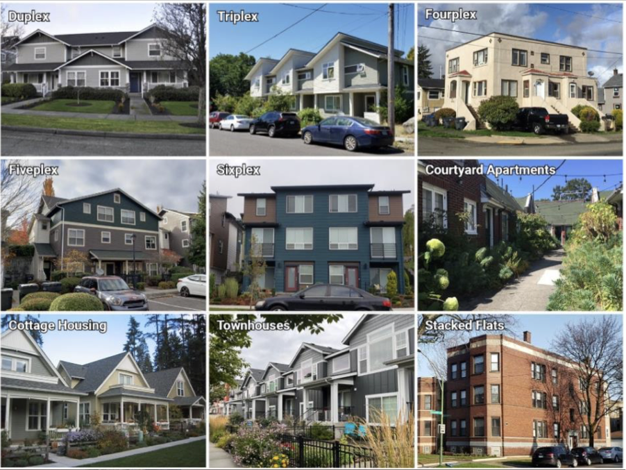
Per HB 1110, large cities must provide authorization for development of “. . . at least four units per lot on all lots zoned predominantly for residential use, unless zoning permitting higher densities or intensities applies . . . .“ and it offers nine different housing types. See the photo below for examples.
Other provisions in the law increase the number of units per lot to “. . . at least six units per lot . . . ”
It’s important to note that the state law only addresses the number of housing units allowed on a lot (and some parking restrictions in certain areas), but not exactly how the zoning specifics (building setbacks, lot coverage, height limits, etc.) are determined. That is up to each city to decide.
Single-family homes can still be built in NR zones, but the zoning allows for, and is intended to encourage, multi-unit development.
Nine different housing types offered by HB 1110 and applicable to Zone NR.
Zone LR2
LR2 (Lowrise 2) zoning allows 4-story (40 feet) townhouses and apartments. Proposed property-line setbacks are reduced to 5 feet minimum in front and either 5 or 0 feet in back. Side setbacks remain at 5 feet. See the following table for more information.

Zone LR3
LR3 (Lowrise 3) zoning allows 5-story (50 feet) apartments, some townhouses. Proposed property-line setbacks are reduced to 5 feet minimum in front and either 5 or 0 feet in back. Side set backs remain at 5 feet. Density is also increased via the increased Floor Area Ratio. See the following table for more information.

Proposed Phase 2 Zoning Requirements for Lowrise (LR) Housing

Zone NC2-55
Properties facing three blocks of 24th Ave E, from E Boston St to E Calhoun St, are being rezoned as NC2-55 (Neighborhood Commercial, 55’ height limit). This includes current commercial lots and about a dozen existing residential lots, and it allows mixed-use commercial/residential buildings.

Impacts of reduced setbacks
A setback is the minimum distance a structure can be built from a particular property line. Current residential zoning in Seattle calls for a 20-foot setback for the front yard, and most of Montlake’s houses were built to that minimum requirement. Backyard setbacks are more complicated, but are 20 feet for most lots in Montlake. Side yard setbacks are typically 5 feet.
For Zone NR, the proposed front and backyard setbacks are both reduced to 10 feet. For Zones LR2 and LR3, the front and backyard setbacks are reduced to 5 feet (minimum), or no setback at all for backyards that abut an alley. These proposed changes will significantly reduce the existing tree canopy and natural habitat, increase impervious surfaces and result in higher summer temperatures.
Many of Seattle’s large, mature trees are located within the existing setback areas that would be eliminated with the proposed zoning changes, and developers are allowed to remove most of those trees and replace them according to a complicated point system. Many of those big, beautiful trees provide shade to multiple houses, help with stormwater management, absorb greenhouse gases, provide cooling in the summer, and provide habitat for wildlife. And they’re a big part of why Seattle is known as the Emerald City.
The tree point system is defined on page 51 of the Draft Phase 1 zoning legislation. The tree point system is too complicated to summarize here, so here’s an example: If four housing units were built on a 4,000 square-foot lot, large mature trees could be removed to allow for construction, and the developer would have to plant new trees that add up to 5 points. Planting four small conifers (4-foot minimum height), worth 1.25 points each, would satisfy the replacement requirement. The City also allows developers to plant replacement trees off-site “. . . and/or [make] a voluntary payment in lieu of tree replacement.” Seattle Municipal Code Title 25.11 covers tree protection and replacement.
At least one other consequence of smaller setbacks is reduced or impaired sight lines. For example, when drivers or bicyclists approach an open intersection (meaning no stop sign or stop light), they need to see if anything is approaching on the cross street. Putting buildings 10 or 15 feet farther into front yards will cut down the sight lines and increase the chance of collisions. This is already a problem on the 26th Ave E bicycle corridor, even with the existing 20-foot setbacks.
There are several articles about the One Seattle Plan and its effects on the environment at the beginning of the Additional Resources page.
Proposal for required off-street parking
The latest proposal from OPCD is to follow the new state law, HB 1110. It says no off-street parking is required within one-half mile of a “major transit stop.” For Montlake, it’s roughly the area from Shelby St to Roanoke St, on the north end of the neighborhood. The Link light rail station at Husky Stadium is considered a major transit stop, but our Metro Route 43 and 48 bus stops are not.
Outside of the area described above, the mayor’s proposal for Zone NR is to require one off-site parking spot for every two housing units, except ADUs don’t count toward parking requirements.
It’s not clear what the proposed off-street parking requirements will be within Montlake’s Neighborhood Center (zones LR2, LR3 and NC2-55) because the Phase 2 draft zoning legislation doesn’t contain that information yet. But based on the One Seattle Plan’s Land Use Policy LU5.3 and the all-Seattle rezoning map which indicates 24th Ave E as a Frequent Transit Route, it is very likely that NO off-street parking will be required for new buildings within the proposed Neighborhood Center. If so, parking demand will increase significantly, at least near the new buildings.
About the approval process
The Mayor’s Office of Planning and Community Development (OPCD) started work on the One Seattle Plan in 2022 and transmitted it to Seattle City Council on 1/6/25. After Council review and consideration of public comments, the Council will propose amendments and make them available for a 30-day public review period. Eventually the Plan will be approved and adopted by the Council and will become Seattle’s 2025 Comprehensive Plan. For reference, the City Council will adopt the One Seattle Plan in Council Bill CB 120985, targeted for September, 2025.
Before the City Council can adopt the One Seattle Plan, OPCD’s Environmental Impact Statement must be free of any appeals. The Final EIS was released on January 30. Appeals must be made within 14 days of the Final EIS release date.
The purpose of the EIS is to analyze the impacts of the One Seattle Plan on a range of elements of the built and natural environment including: earth & water quality, air quality/greenhouse gas emissions, plants & animals, energy &natural resources, noise, land use &urban form, plans policies, population, housing &employment, cultural & historic resources, transportation, public services and utilities. For each element in the EIS, the analysis determines the likely impacts and outcomes, and proposes mitigation options for consideration.
According to the Executive Summary of the EIS, all of the elements listed in the previous paragraph were determined to have “no significant adverse impacts expected,” except for noise, cultural & historic resources, and transportation.
Six appeals were filed within the 14-day appeal period. All appeals were dismissed by the Hearing Examiner on April 11, 2025 in this document.
The new zoning regulations also have to be created by OPCD and approved by the City Council, but those are transmitted to the Council separately from the Plan, and in two phases. Phase 1 zoning is targeted to comply with new state law HB 1110, and was intended to be in place by June 30, 2025 to meet a State requirement. This will apply Zone NR to most residential lots in Seattle. Phase 1 also includes the adoption of the One Seattle Plan.
If Phase 1 zoning legislation is not in place by June 30, a state zoning law called the Middle Housing Model Ordinance would automatically take effect. It has zoning requirements similar to those proposed Phase 1, but they are not identical. See the Additional Resources page for more information.
To avoid having to use the Model Ordinance, OPCD created “Interim” Phase 1 legislation and the City Council approved it prior to the June 30 deadline. This was done in Council Bill CB 120969. Final legislation to comply with HB1110 is being addressed in Council Bill CB 120993, targeted for September, 2025.
On August 8, 2025, City Council released 110 amendments to the two council bills associated with Phase 1 legislation (CB 120985 and CB 120993, both mentioned above). Many of those amendments are aimed at increased density, increased building height, reduced setbacks, increased usage of “corner stores” in residential neighborhoods, reduced parking requirements, enhanced tree protection, as well as changes to some Neighborhood Center boundaries (not including Montlake’s) and creation of new neighborhood centers.
Somehow the interim zoning legislation (CB 120969), which was only 85 pages long, became 360 pages in the permanent legislation (CB 120993). According to City Council, the public may provide comments on the 110 amendments, but may not comment on anything in the bills that is not the subject of one of the amendments. There will be a public hearing on 9/12 followed by the select-committee voting on the amendments on 9/17 through 9/19, but the modified amendments will not be available to the public until after the public hearing.
Several members of the Montlake Rezoning Task Force studied the amendments and made comments and recommendations to City Council based on months of feedback received from residents and others, such as Seattle tree-protection advocates, and those are available on the September 2025 Status page. There was an overwhelming amount of information to study in the short time the amendments were available for review and comment. It’s hard to believe the process has been rushed so quickly when the changes to Seattle’s zoning will have such an enormous impact.
As mentioned above in the Neighborhood Center section, Phase 2 zoning will define Neighborhood Center zoning types on a block-by-block basis, as well as providing the full definition of each zoning type in terms of building height, number of stories, density, setbacks, Floor Area Ratio, off-street parking requirements, etc. OPCD expects to transmit Phase 2 zoning legislation to City Council in the fall of 2025 or early 2026. Phase 2 zoning also affects Urban and Regional Centers, which are bigger and denser than Neighborhood Centers. It also rezones lots near arterials for higher density in a “corridor” approach. Lots on 24th Ave E between Newton St and Boyer St could be affected by this.
The proposed zoning legislation for Phase 2 is still in work at OPCD. A link to draft legislation for Phase 2 zoning is found on the Additional Resources page, but this will get a massive update before being transmitted to Council.
State laws and regional policies
HB 1110:
This House Bill is a new state law passed in 2023 that affects most cities in the state. It requires cities to create zoning that allows multiple housing units on “all lots zoned predominantly for residential use.” It allows building at least four to six units on most residential lots in cities with more than 75,000 residents. This presentation shows how Seattle plans to comply with HB1110 by creating the new Zone NR, and it defines what “middle housing” means.
HB 1220:
Addresses emergency and affordable housing
HB 1181:
Addresses growth impact on climate change
Vision 2050:
Puget Sound Regional Council’s growth plan
Other laws and policies may apply.
Learn more on other MCC Rezoning pages
The contents of this webpage were assembled by a small group of Montlake Community Club members to help educate the neighborhood about upcoming zoning changes proposed by Mayor Harrell. Any opinions expressed are not necessarily representative of the greater Montlake community.