Stay Connected with the Latest Information & Options to Contact WSDOT:
- Receive weekly WSDOT email about the project
- Checkout SR 520 Construction Corner and SR 520 Homepage
- Attend SR 520 Monthly Montlake Construction Update Meetings (Virtual)
- Wednesdays at 12:30pm – Register here
- Hear about the project’s status, design updates, and upcoming construction activities. Get questions answered related to the project. May 2024 Meeting: Zoom Recording
- Follow on X: @wsdot_520
- View Montlake Project construction photos taken around the clock by four mounted cameras
- Learn about the Portage Bay Bridge and Roanoke Lid Project
Contact WSDOT:
- Email SR 520 staff: sr520bridge@wsdot.wa.gov
- Montlake Project construction 24 hour hotline: 206-775-8885 (call or text)
- SR520/I-5 Connection Project construction 24 hour hotline: 206-316-2559 (call or text)
- David Goldberg, Community Liaison & Project Ombudsman
- david.goldberg@wsdot.wa.gov
- 202-412-7930
Past Meeting Information on Montlake Blvd Signs:
In response to community concerns about the newly installed Montlake Blvd signs, WSDOT has set up an in-person (and virtual) meeting at 5:30 p.m. on October 26 at the Queen City Yacht Club to share sign design context, answer questions and gather your feedback for potential signage adjustments.
-
- Date: Thursday October 26
- Time: 5:30 – 7 p.m. (doors open at 5:15 p.m.)
- Location: Queen City Yacht Club (2608 Boyer Ave. E)
- Parking: Attendees can park in the QCYC parking lot or on the street. Please be advised that the gates to QCYC will close after the meeting.
- RSVP to attend link: https://survey.alchemer.com/s3/7545917/Montlake-Project-Signage
- Survey closed on October 18
Community responses regarding newly installed Montlake signs:
Friends of Seattle’s Olmstead Parks (FSOP) submitted 10/20/23 to WSDOT:
Dear Cassie and Omar:
I am responding on behalf of Friends of Seattle’s Olmsted Parks (FSOP) regarding the Sign Bridges for the SR520 Project in Montlake. I serve as a representative of FSOP at the 106 Concurring Parties meetings related to SR520.
The attached PDF illustrates our concerns and recommendations for the traffic signage currently being proposed to be handled on the Sign Bridges.
Background
As a matter of clarification, since I have been involved on the SR520 project since the time of serving on the Trans-Lake Washington Study Committee, there has not been, as far as I am aware, discussion of the traffic signage or previous opportunities at 106 quarterly meetings to give feedback on how to minimize its impacts on the historic boulevards. FSOP as a Concurring Party focused on the historic character of the boulevards should have been part of any discussion and review. I think it is important to look comprehensively at the proposals for traffic signage on the boulevards, so as to minimize the visual impact and redundancy.
Given that Montlake Boulevard and Lake Washington Boulevard are primarily neighborhood roadways and important historic resources, taking care to minimize the intrusion of signage and structures needs to be a priority. Typical highway signs are designed for 60-70 mph speeds, but that is not the case on these neighborhood boulevards where speeds are slowed with traffic congestion to even less than the City’s standard 25-30 mph and long sightlines do not exist. Most users know the area and the access points well so having redundant signage is not needed, once any new route adjustments have been learned.
Recommendations
Our recommendations are to use the Signal Mast Arms for any needed signage and where helpful use lane paint to augment the signage. The first set of illustrations show mock-ups of the signage for the Signal Mast Arms that would accomplish the same information as the Sign Bridges, but at a much more suitable scale. The mast arm graphic is based on one at Grady Way SW and Rainier Avenue just north of I-405.
The last three pages showing the three Sign Bridges are included to show an initial look at ways to reduce the scale of the signs themselves on the Sign Bridges. But the negative reaction to the Sign Bridges – their size and scale – was so strong as being totally out of context with the effort to keep some semblance of scale of the historic boulevards and neighborhood, we cannot recommend their retention.
We want to request that before moving forward with traffic signage that we have an opportunity to review comprehensively the proposed traffic signage on Montlake Boulevard, Montlake Place and Lake Washington Boulevard, so as to minimize unneeded redundancy and visual clutter and assure signage is scaled in keeping with the historic resources. We suggest this as we believe there is value in getting feedback early in a process so as not to have to undo actions that did not benefit from input from other perspectives.
We look forward to hearing from you, following your public meeting next week which unfortunately we are not able to attend, about next steps in this requested review process of the overall traffic signage on the boulevards.
Thank you,
Anne Knight for Friends of Seattle’s Olmsted Parks
SR520 Montlake Sign Bridges Mast Arms – 2023-10-20 FSOP
Construction Information from 2016 and Earlier:
WSDOT Monthly Construction Meetings are held the first Wednesday of the month at the Graham Visitors Center from 5:30 to 6:30 p.m.
- Latest News & Monthly Construction Meeting Reports
- Current Seattle Concept Design, Recommendations & Process
- Construction Phases
- Frequently Asked Questions
- Links + Contacts
Latest News & Monthly Construction Meeting Reports
- 04/01/2016 [Flyer]: 520 Grand Opening – April 2nd & 3rd
- 10/23/15 [Flyer]: Oct. 24 – 25 Weekend Closure of the Montlake Bridge
- 09/16/2015 [Flyer]: SR 520 Resolution Meeting
- 09/04/2015 [Flyer]: 24th Ave East Bridge to Close Sept 8th
- 09/03/2015 [Flyer]: SDOT Seeks Input on Bridge Openings
Current Seattle Design, Recommendations & Process
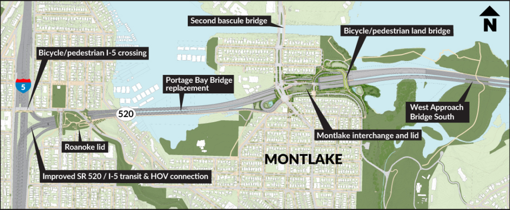
January 16 2015, WSDOT and the city of Seattle released a draft design report containing the final conceptual design recommendations for improvements to the SR 520 corridor in Seattle. Planned but still unfunded improvements in this west side section of the highway include a new Portage Bay Bridge, the new west approach bridge south, lidded overpasses in the Montlake and Roanoke neighborhoods, and enhanced facilities for bicyclists, pedestrians and transit riders.
The Public Comment Period will close on February 13, 2015. You may leave comments here, submit comments via email to representatives list below or visit the online survey.
In 2012 WSDOT conducted the Seattle Community Design Process to collect public feedback on design options for the phases listed above. From that process, WSDOT heard loud and clear that the plan for the Montlake interchange, including its landscaped lid, needed more work. A lot more work. In February 2013 the Seattle City Council passed Resolution #31427 formally asking WSDOT to study a “wider range of options for the Montlake Lid” and specifically to improve the walking and biking connections throughout the area.
WSDOT’s final (2012) Seattle Community Design Process report is here (85 pages, 24Mb PDF). Enjoy that. Here are WSDOT’s preferred plans for the Seattle side, as of the last design update in 2012. Click to enlarge.
Construction Phases
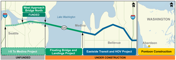
WSDOT is replacing 520 as funding becomes available, which means construction work is happening in several phases:
- West Approach Bridge North, WABN (September 2014 — 2016) — A new 3-lane elevated viaduct adjacent to the existing West Approach, connecting the western high-rise near Madison Park Beach to Montlake Blvd. Together this new structure and the existing West Approach will each have 3-lanes during the interim period until the entire 520 corridor is replaced. Funded with a $300 million federal loan.
The rest of the Seattle-side 520 replacement remains unfunded to the tune of $1.4 billion so the construction schedule is who-the-hell-knows.
Toward A Connected Montlake Lid
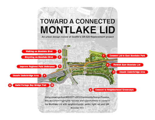
Alternatively, an independent analysis of the 2012 design for the Montlake area, called Toward A Connected Montlake Lid, points out 10 problem areas in the lid design and makes suggestions for improvements. Click here to check it out.
Design work has re-started in 2014, following up on City Council Resolution #31427 to explore “a wider range of options” for the Montlake Lid. WSDOT is expected to hold a public open house in September 2014 to unveil updated designs.
Frequently Asked Questions
Where is the mitigation we were promised? — Since funding and construction happens in phases, the mitigation projects also are funded in phases. The Seattle-side lids are expected to cost hundreds of millions and have to be built after the mainline highway is constructed. Don’t expect them to happen anytime soon. There is mitigation included with the $300 million WABN phase, including: the Arboretum Multi-Use Trail, a new Portage Bay park for UW at the Bryant Building, and wetland restoration work at the WSDOT Peninsula.
Will there be a bike path on the future Portage Bay Bridge? — Yes. WSDOT received “overwhelming” support during the 2012 design process to include a walking and biking path on the future bridge. This is excellent news for people who think transportation infrastructure should also support non-carbon producing ways of getting around town.
What is the City’s role in all of this? — The City of Seattle is partnering with WSDOT to help guide the project toward “Seattle values”. Two point persons working within City administration are leading this effort: Lyle Bicknell, Department of Planning and Development; and Bernard Van De Kamp, Department of Transportation. WSDOT’s design team will present to the Seattle Design Commission throughout 2014.
What’s happening with the proposed Second Bascule Bridge? — Not much. A 2012 Montlake corridor traffic analysis concluded that adding more automobile lanes over the Montlake Cut would not improve traffic because the real culprits to congestion are the inefficient intersections before and after the bridge. So the Seattle City Council voted to table consideration of a second bascule bridge “for the foreseeable future.”
What’s up with the Coalition for a Sustainable 520? — The Coalition was a group of people from six neighborhood surrounding the 520 corridor that sued WSDOT over Governor Christine Gregiore’s 2010 decision for the Perferred Alternative, a six-lane highway blasting through Montlake. The lawsuit was rejected by a federal judge in 2012. In the spring of 2014, the Coalition re-branded as a group called Respect Seattle.
Links + Contacts
WSDOT SR-520 Home Page. Sign up for email updates about the SR 520 program.
WSDOT SR-520 West Approach Bridge North Project Page
WSDOT Seattle Community Design Process
WSDOT SR-520 Orange Page (for construction news and closures, not very orange)
Want to have your voice heard? Send comments to….
- WSDOT’s 520 team: SR520bridge@wsdot.wa.gov
- Mayor Ed Murray: ed.murray@seattle.gov / @Mayor_Ed_Murray
- Tom Rasmussen, City Council Transportation Committee: tom.rasmussen@seattle.gov / @CityHallTom
- Mike O’Brien, City Council Transportation Committee: mike.obrien@seattle.gov / @CMMikeOBrien
- WA State Legislative Representatives, 43rd District
Jamie Pedersen: Jamie.Pedersen@leg.wa.gov
Brady Walkinshaw: Brady.Walkinshaw@leg.wa.gov
Frank Chopp: Frank.Chopp@leg.wa.gov


