Cyclists and walkers – the new, temporary shared-use connection between the SR 520 Trail and Lake Washington Boulevard is now open. This bicycle and pedestrian path runs parallel to the temporary on-ramp from Lake Washington Boulevard to eastbound SR 520 and dips under SR 520 along the shore of Lake Washington.
![An aerial view of SR 520 in Montlake. There is a yellow line labeled new bicycle pedestrian route under the highway.](https://ci6.googleusercontent.com/proxy/rtyLjWhuSeK49waWAidjkxcRutk8s1m0sdrfbJnpVEt5nfvGS2gOj7FtmhYGgFvr3CVhlIoP6yvr9lPK8Gj_TDYtDBUtCaAbU4MF-TA6QqrHOngK6f_FzE3VneHwYvO8A033qqd9AfyrJ_f5plzQ-QieUgdvOrGo2w1srBT4SsEkjnJE9R2zR-qk4jEEynLgB6GQvQT_7928rg0dbMEmPA=s0-d-e1-ft#https://content.govdelivery.com/attachments/fancy_images/WADOT/2020/03/3210740/2999898/sr520-picture-aerialmontlakeunderbridgetrail_crop.jpg)
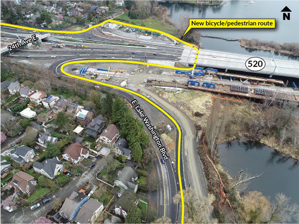
With this separated path, cyclists and pedestrians can go under SR 520 instead of using Montlake Boulevard, connecting the Arboretum with the University of Washington and the east side of Lake Washington.
![A map of Montlake. There are many bike routes labeled, including a new bicycle pedestrian route under 520 east of 24th.](https://ci5.googleusercontent.com/proxy/--JQeXWs-hjl4rPewyY4UHncDjNQ4FoFWxs9QnYKKyj6VVkd5FdCMnFBcYtEQZOrqZfAD74_Z0rAcTLM_6B6v4H87YQngRw2-FdN3HKbK0uaONB5Tp8RA6PUf7HDy6BBakchv4Q1uEKWOjx_Mcjic3CYcXs8zln0WhG6lOFAF-V6Utyk5ln3bNV5ESzmTlXe8rQ=s0-d-e1-ft#https://content.govdelivery.com/attachments/fancy_images/WADOT/2020/03/3210742/sr520-map-under520bikeroutemontlake_original.jpg)
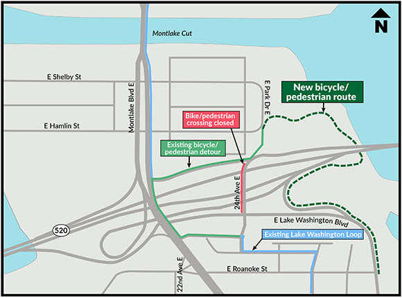
The temporary trail will be in place for the next few years of construction. At the end of the project, the temporary trail will be replaced by new connections and route options.
Leave a Reply